
 by Caitlin Snow
Hurricane Lee continues to track north.
Environment Canada has now issued a Hurricane Watch for:
Digby, Yarmouth, Shelburne and Queens Counties in Nova Scotia, as well as Grand Manan and Coast Charlotte County in New Brunswick with near hurricane conditions Saturday.
The forecaster says wind gusts could be up to 120 km/h in those areas with sustained winds at 120 km/h or more.
This includes significant elevated water conditions along the coast and local flooding due to heavy rainfall.
A Tropical Storm Watch is in effect for:
Saint John County, Fundy National Park, and Moncton and Southeast New Brunswick, as well as Annapolis, Kings, Lunenburg, and Hants Counties, Halifax Metro and Halifax County West, Cumberland County – Minas Shore, and Colchester County – Cobequid Bay in Nova Scotia.
This includes tropical storm force winds of 60 to 90 km/h and possibly 100 over exposed areas.
Nova Scotia Power
Nova Scotia power encourages customers to have an emergency kit ready they already extra staff getting prepared.
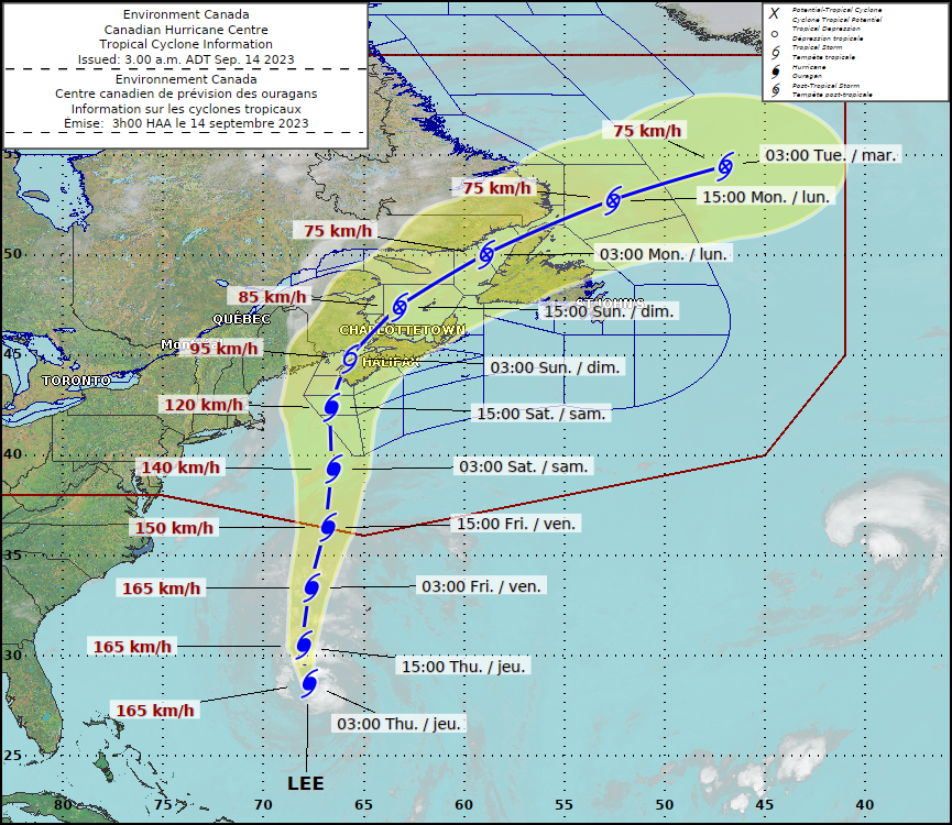
Lee’s Track
The latest model from the Canadian Hurricane Centre shows Lee approaching the Maritimes as a hurricane and making landfall as a tropical storm, continuing north as a post tropical storm.
Environment Canada says Lee will continue to track north toward the Maritime provinces and New England Thursday and Friday. Lee is expected to gradually weekend as it approaches the Gulf of Maine later in the day, Saturday.
The centre of the storm could make landfall anywhere from Downeast Maine to western Nova Scotia as a strong tropical storm, or post-tropical low, late Saturday night or early Sunday. The system, however, is large and powerful and will hit well away from the centre.
Environment Canada says “In addition to Lee, the Maritime provinces may experience bands of training downpours travelling from southwest to northeast. These bands are notoriously difficult to predict but it is important to understand there is a flooding risk with these bands well before the arrival of Lee. These complex effects are indirectly related to the hurricane. Additional rainfall from Lee itself could exacerbate the risk of flooding.”
Most Impacted
Wind:
Western Nova Scotia, Grand Manan and Coastal Charlotte County will get the most wind.
Rainfall:
Western New Brunswick and northward into parts of Bas-St. Laurent and Gaspesie Regions of Quebec. The threat of heaviest rains for southwestern Nova Scotia is increasing, with 100 mm or more possible.
Surge/Waves:
Atlantic Coast of Nova Scotia and Fundy Coast of New Brunswick
Warnings:
The biggest waves and winds expected for the Bay of Fundy, Gulf of Maine and southwest Maritimes marine district.
“Gale and Storm warnings are in effect for southwestern marine areas beginning late in the day on Friday. Hurricane force winds are likely to impact southwestern waters on Saturday.”
More information to come…